Some historical events feel inevitable in hindsight. It’s easy today to look back and think, “Of course that was going to end badly.” The Johnstown Flood of 1889 is one of those events. It wasn’t just a natural disaster; it was a perfect storm of engineering shortcuts, wealthy egos, ignored warnings, and a valley full of people who deserved far better.
To understand why the flood happened, you have to understand the people who built the dam, the people who “improved” it, and the people who paid the price.
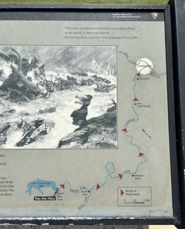
Getting to Johnstown, Pennsylvania
The flood route from the dam to Johnstown
The nearest major airport is Pittsburgh, PA, which is about two hours from Johnstown. If you’re on the east coast it’s about three hours’ drive from Baltimore or Washington DC.
Canals were booming in Pennsylvania in the 1830’s but there was a problem with drought in the summer and a more consistent water supply was needed. Engineering surveys ironically identified the South Fork area as the safest place for a dam. However, work stoppages throughout construction delayed progress and it took 10 years to complete the dam.
Finally completed in 1853, the South Fork Dam was viewed as a critical part of the state’s canal system. For over 20 years, the canals had been a boom to moving goods quickly throughout Pennsylvania. To understand how goods were transported before canals, check out this post on the Conestoga Wagon.
The dam created Lake Conemaugh to provide water during dry summers. The lake would store and release water to the Conemaugh River and other waterways in the region. The lake stretched for 2.5 miles over 450 acres and was 70 feet deep in some places. The water in the lake weighed 20 million tons.
The original engineers who built it were mindful of the potential for flooding and included several features to prevent or minimize damage.
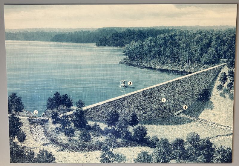
These measures included: a massive earthen embankment to contain the water, a stone spillway to safely release excess water if it did get too full, and a carefully calculated height to withstand heavy rains.
Illustration of the South Fork Dam including safety features 1) packed earthen wall, 2) large spillway 3) flow control tower and 4) discharge pipes to regulate water level. Source: informational board at NPS Visitor Center, author photo
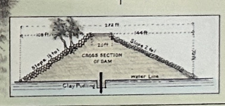
Cross-section drawing of the original South Fork Dam, showing safety features from the height, the earthen embankment, and a stone spillway.
Unfortunately, the canal system was already losing to railroads out by the time the dam was completed. By 1854, only a year after the dam was completed, the Pennsylvania Main Line Canal company went out of business and closed its doors.
Within 20 years the canals fell by the wayside in favor of shipping goods by rail. As a result, the South Fork Dam was abandoned and nature slowly because to reclaim the structure.
Enter the millionaires.
The South Fork Fishing and Hunting Club: Where Millionaires Vacation and Dams Go to Die
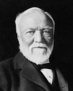
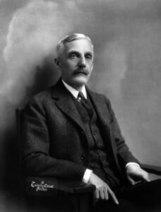
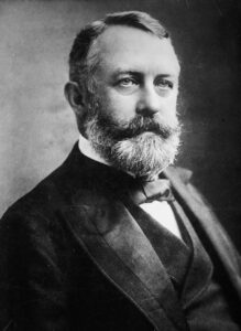
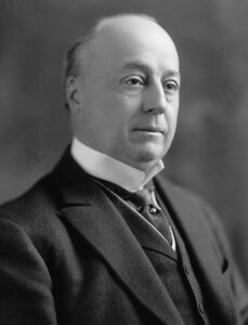
By the 1870s, the neglected dam and the land around it were purchased by a group of Pittsburgh industrialists who wanted a private mountain resort. This was the Gilded Age, when fortunes were made in steel, coal, and railroads, especially in the hills of Western Pennsylvania. It was a time when the ultra‑wealthy loved nothing more than a secluded lake where they could fish, drink, and congratulate each other on their riches.
Andrew Carnegie
Andrew Mellon
Henry Clay Frick
Philander Knox
The South Fork Fishing and Hunting Cub was created for this purpose, and members included names you may recognize as men who shaped American industry in the Gilded Age:
Andrew Carnegie, steel titan
Henry Clay Frick, industrialist and future strike-breaker
Andrew Mellon, banker & future US Treasury Secretary
Philander Knox, future US Attorney General and Senator
The club did repair the dam from years of neglect, but their ‘repairs’ removed many of the original design features that kept the water in check.
Dam Modifications Led to the Johnstown Flood
The industrialists wanted to maintain the lake for their sporting activities, but they wanted to keep costs down. As a result, their “repairs” to the dam included:
Lowering the dam to make room for a carriage road
Removing the original drain pipes (which made it impossible to divert water in an emergency)
Installing fish screens to improve their sport but clogged in heavy rain
The People Who Tried to Sound the Alarm
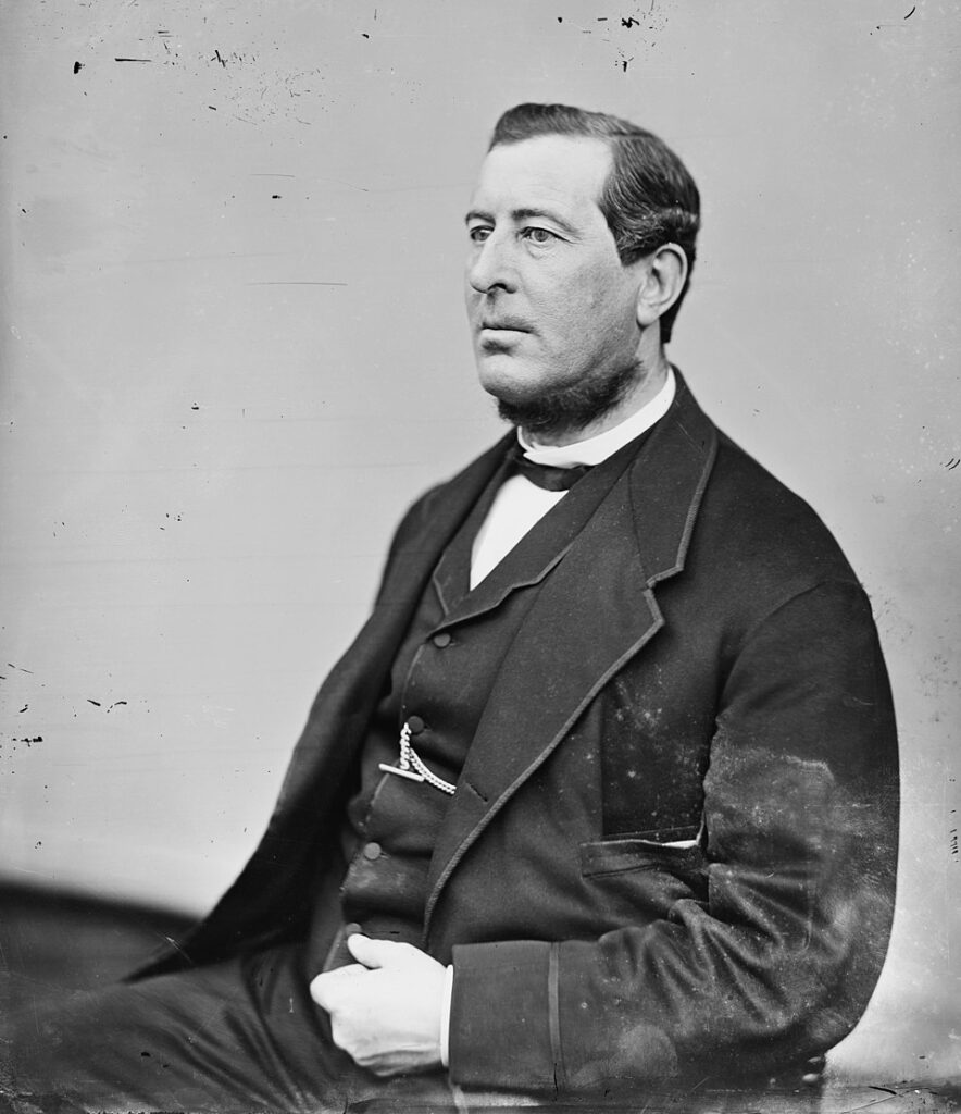
Daniel Morrell, iron industrialist who tried to warn the club about the dam
It didn’t go unnoticed that the changes to the dam by the Club were compromising the structure.
Daniel Morrell, president of the Cambrian Iron Works in Johnstown and member of the South Fork Fishing and Hunting Club, repeatedly warned the organization that the dam was unsafe.
He even went as far as to have one of his engineers inspect the dam in 1880. His engineer reported the unsafe conditions and recommendations for modifications, which Morrell offered to pay for, but was turned down.
Morrell died in 1885, four years before his warnings were confirmed by the Johnstown Flood.
May 31, 1889: The Day Everything Gave Way
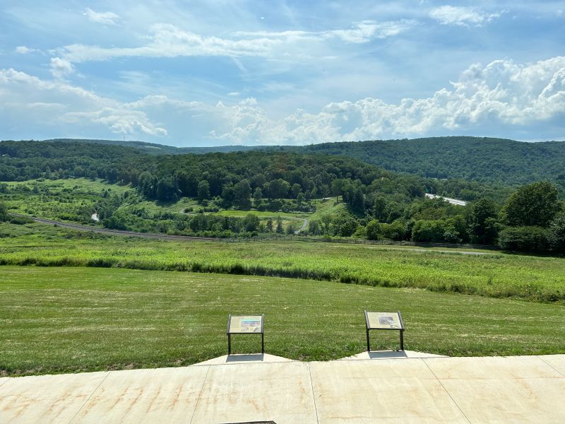
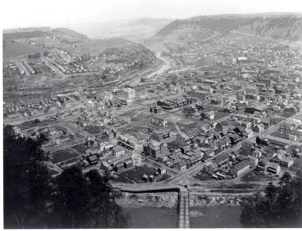
Today all that is left of the dam is a small earthen mound (just to the left of the highway in the center right of the photo). In 1850, the entire valley on the left side of the photo would have been under 3.6 BILLION gallons of water.
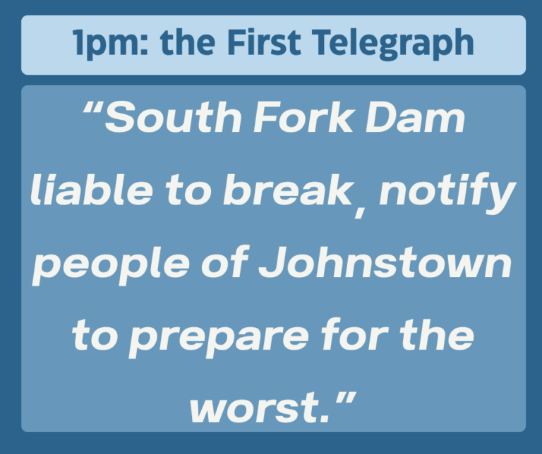
At the end of May in 1889 it rained. A lot. After several days of torrential rain, Lake Conemaugh was swollen to the brim. Club employees noticed leaks and attempted emergency repairs, but without the original drainage pipes, there was no way to relieve pressure.
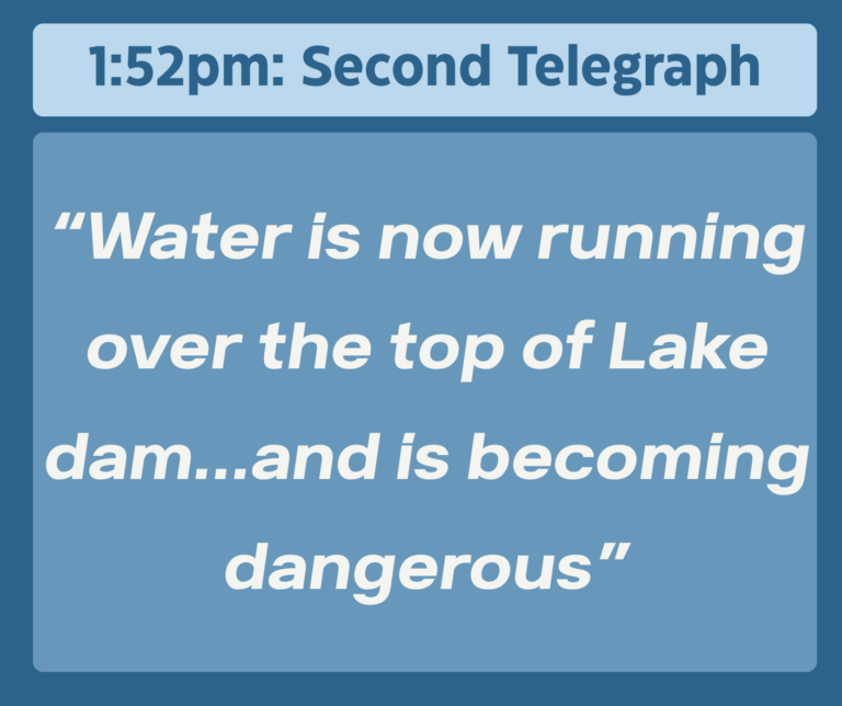
By 7am on May 31st, the water was only 6 feet below the top of the dam. By 8am it had risen another 2 feet and the rain was not letting up. By early afternoon it was understood that the situation was dire, but townspeople had had false alarms before and they did not heed warnings to evacuate.
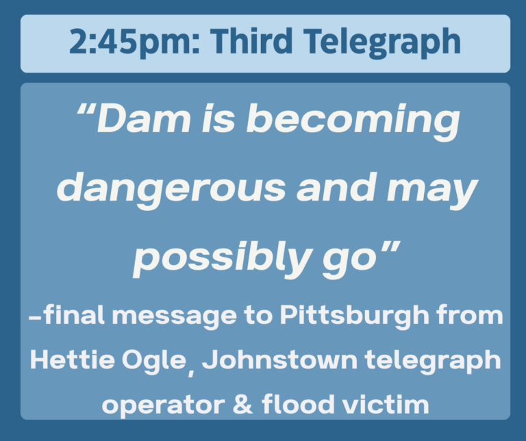
The president of the South Fork Fishing and Hunting Club sent workers to cut and extra spillway but it wasn’t enough. By 2pm a large section of the earthen dam was washed away.
At 3:10pm the dam failed and the water was released.
The valley constricted the rush of water, at times creating a wall of water 70-75 feet high and surging to speeds of 40 miles per hour. Debris would choke the flood at times, almost stopping it with a dam of debris at one point but it broke free again.
It took 40 minutes for the water to fully drain the lake. 57 minutes after the South Form Dam broke, Johnstown was hit with a wall of water 36 feet high as 3.6 billion gallons of water reached the town.
Aftermath of the Johnstown Flood
The official death toll was 2,209 but the true toll will never be known. 99 entire families were lost.
Bodies from the flood were found as far away as Cincinnati, Ohio and as late as 1911.
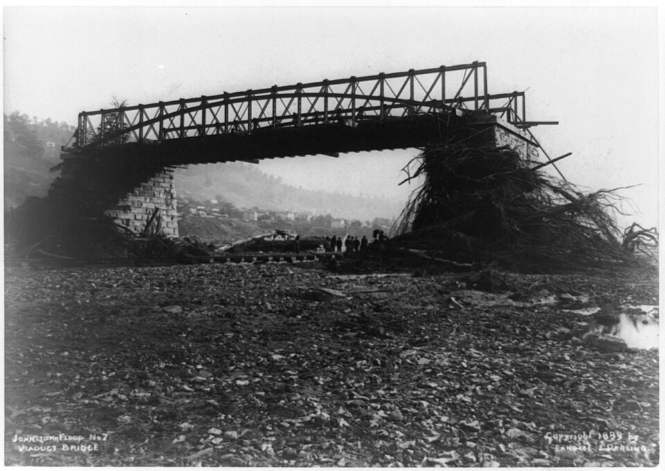
Viaduct ruins in Johnstown.
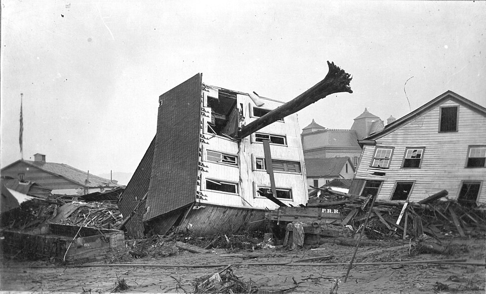
The force of the water uprooted massive trees and threw houses from their foundations.
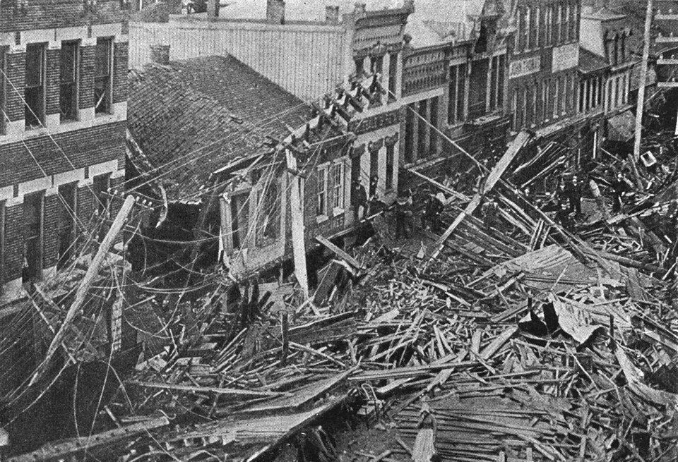
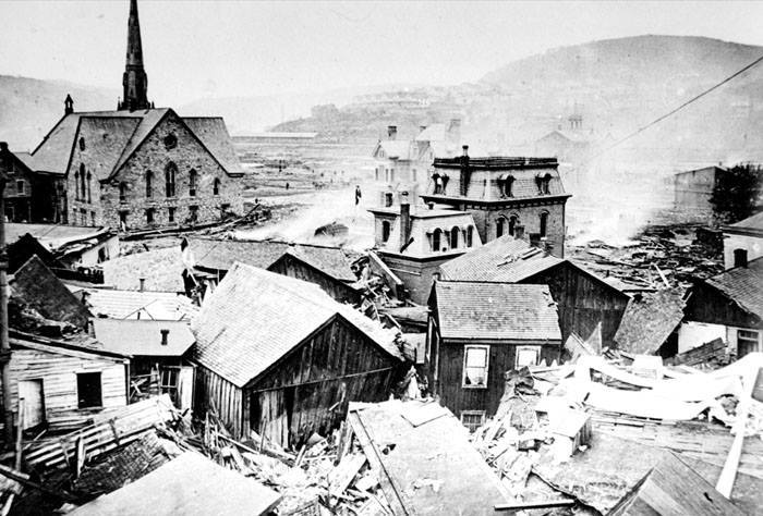
Main Street of Johnstown after the flood.
Looking down Main Street Johnstown.
Nothing in the path of the water was spared in Johnstown.
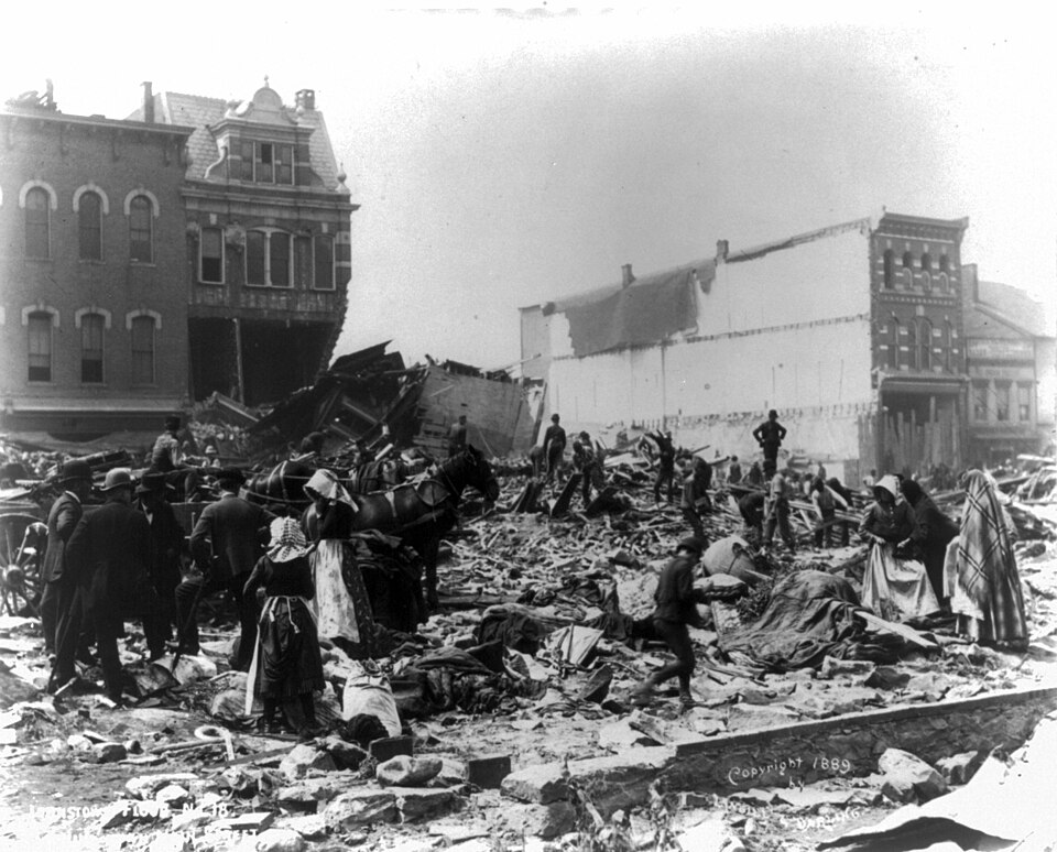
A birds eye view of the damage from the Johnstown Flood.
Clara Barton, 1904
Clara Barton, then in her late 60’s, brought her Red Cross organization to Johnstown. It would be the first major US disaster that they would support.
Barton and the Red Cross stayed in Johnstown for five months, creating field hospitals, temporary housing, and food & clothing distribution centers.
There was an inquiry, but the courts deemed the accident an “Act of God” and did not hold anyone accountable. Public outrage did inspire later changes in liability laws eventually but it was too late for the victims of 1889.
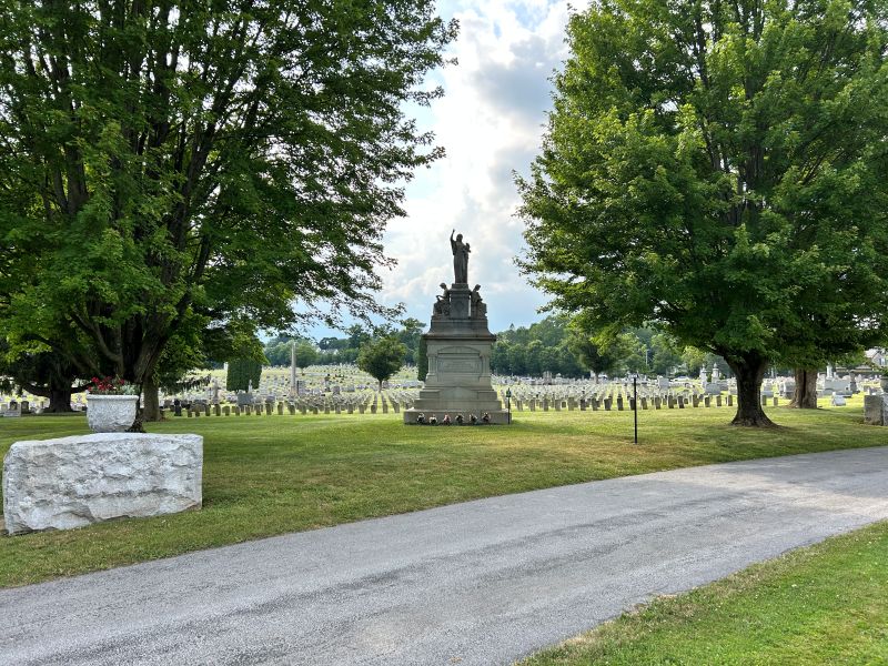
Grandview Cemetery: Where the Story of the Flood Settles Into the Landscape
If the Johnstown Flood is a story of overwhelming force, Grandview Cemetery is the quiet counterpoint. It’s a place where the scale of the tragedy becomes personal. Perched on a hill overlooking the city, the cemetery predates the flood by nearly two decades, but its identity is inseparable from what happened on May 31, 1889.
When the waters receded and the staggering death toll became clear, Johnstown faced a heartbreaking logistical reality: there were simply too many dead. Grandview became the central burial ground for victims, and its role in the aftermath was both practical and symbolic. It offered a dignified resting place at a moment when the town was struggling to regain any sense of order.
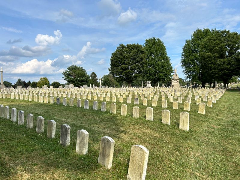
The Grandview Cemetery has a large section with headstones to the unidentified. As striking a that is, look around and you'll soon see how many more graves there are for victims that were identified. Look for tombstones with the date of death listed as May 31, 1889.
One of the most striking areas of Grandview is the Section for the Unknown Dead, a circular plot containing the graves of more than 700 victims who could not be identified. The floodwaters had been so violent, the debris so tangled, and the destruction so complete that many bodies were recovered with no way to match them to names.
In the center of the plot stands a monument dedicated to these unknown individuals. I highly recommend a visit to the cemetery if you visit this area.
The "Unknown Plots" of more than 700 victims of the Johnstown Flood who could not be identified.
Another Vantage Point: The Johnstown Inclined Plane
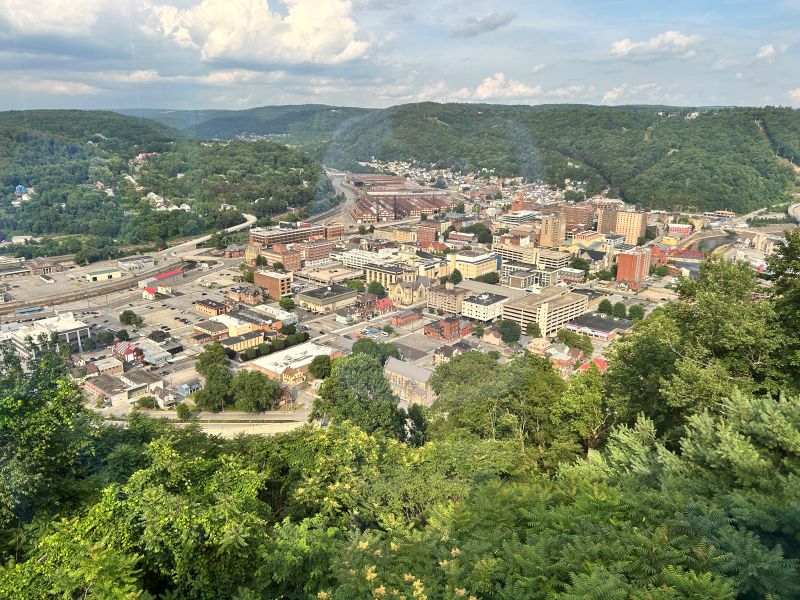
If Grandview Cemetery is where the human cost of the flood settles into the landscape, the Johnstown Inclined Plane is where you can step back and see the geography that shaped the disaster in the first place. Built in 1891, just two years after the flood, the Inclined Plane wasn’t designed as a tourist attraction. It was built for survival.
Johnstown sits in a narrow river valley, surrounded by steep hills that look picturesque until you remember that water has only one direction to go: down. After the 1889 flood, city planners realized that residents needed a fast, reliable way to evacuate to higher ground during future disasters. Their solution was both practical and ambitious: construct the world’s steepest vehicular incline.
View from the top of the Inclined Plane
And it worked. Johnstown flooded again in 1936 and 1977, and the Inclined Plane helped evacuate residents and transport supplies.
It’s one of the few pieces of infrastructure in American history that was built because of a disaster and then went on to save lives in later ones.
From the top, the view is panoramic. You can trace the path the floodwaters took as they barreled down the valley. You’ll also see how the rivers converge in a tight, unforgiving space.
It’s a perspective that makes the flood’s scale suddenly, almost shockingly clear.
There’s a nice little museum at the top as well as a restaurant which I didn’t get a chance to try when I visited. The tram itself is closed for a major refurbishment, but you can drive up to the top to visit the museum and see the views.
Original historic designs now available in my Etsy shop: EpochApparelDesigns
Off on a history adventure? I design shirts for history babes and history buffs, so check it out!